
Go | New | Find | Notify | Tools | Reply |
| Banned |
TL;DR: ABC watches aren't for the naive or beginners. They will get you into more trouble not understanding what they can do wrong. Altimeter Barometer Compass watch, is where the niche started, using cell phone sensors to display altitude, barometric presssure, and magnetic North. Great idea for hikers, military, outdoorsmen. Or, so you would think. Some include a temperature sensor, and a lot of that went into GPS watches when the tech finally hit. Owned a Timex WS4, a large square display watch still overpriced on the secondary market. Mine would not zero the altitude sitting on the beach. Not. That model had "intuitive" menus and no owners manual was ever published or issued by Timex. This is what got me into the following: We expect too much from the technology, and some of the official administration of data is deceptive. Temperature: most watches offering that now state "Take it off your wrist for 30 minutes to get an accurate reading." Because if it is on your wrist, skin temp is often 92F, which throws it off. You take it off to get the ambient air temp, not you, or whatever you have it sitting on, such as a dark brown picnic table which can be warmer due to the sun. Altitude/barometer: These are closely related and influence each other. Basically the sensor reads air pressure, if you climb or descend 1,000 feet the pressure changes and it can measure and display it. It needs to know the current barometric pressure at that location to measure it, and that is also variable due to weather and temperature. Many set the barometer to the weather in that area, here's the tech glitch: meteorology zeros to sea level and that artificial number is what they broadcast. I live at a location 1,000 feet above sea level, but the weather stations all display Pressure at Mean Sea Level, and if you use that number, it throws the computations into error. Your input is way off, those who live in Denver at 5,000 feet are a bit more experienced dealing with this. Galveston is at 23 feet, acceptably minor difference. This issue is why so many curse their ABC watch for not displaying accurate changes. It's a rigged system and the actual pressure is a bit harder to find. Another problem with ABC watches is if they switch the A/B display due to movement - you stop, eat lunch, its set to swap, and then, it does - it plugs in a new reading, replaces your accurate input, and now the watch reads wonky. Goes to "be careful what you enable in the menus." Compass: It reads magnetic north, and has to be calibrated by turning it 360 to zero it. My Casio did and had to be reset periodically. First problem - mag North moves. It changed in my location over the last 40 years from 6, to 1 degree to the East. That means the compass will read slightly off (much worse in some areas) and if you walk a mile holding to the direction precisely you could be off by as much as 100m to one side or the other. That's a football field - and in some rugged terrain you may not even see where you really wanted to go. There's another problem - miles or meters? Geo maps are usually meters. Time to get used to the metric system. Where will this watch get used? In the outdoors, of course, which means getting wet. And people would prefer not to lose it, they need to wear it swimming, or underwater for depth measurements, and in the shower - so you don't forget it (ask me how I know.) It needs a good water resistance rating. Another tech issue: there is no such thing as a "waterproof" watch, advertising law prohibits using the phrase, and the reason is that however "proof" it may be, deeper water may kill it. More pressure - beyond what it was designed to withstand. Like "bullet resistant" vests, there are ratings, and above a certain point, nothing is artillery proof that is humanly wearable. To compound the confusion, there are 2, two, rating systems: WR + meters in depth, which is selected by the Maker as a marketing feature, and Dive, which is number of meters with M, such as Dive 200M, and the watch is engineered for SCUBA diving to that depth and the individual case tested to check it actually will before completion. In an air pressure chamber not actually under water. Lets add that for most intents and purposes divers rarely carry enough air to go more than 180 feet - 60M - because it takes so long to decompress coming back up. You have to keep the dissolved air from creating bubbles in your bloodstream and causing a very painful condition known as the 'bends', something the workers hand shoveling the foundations of the Brooklyn Bridge suffered and died from. The engineers finally fixed it by having the workmen stop at stages to simply decompress. Reduced the turnover a lot. When these two different systems are sold side by side the consumer gets the wrong impression and thinks a WR30 rating is capable of skindiving with that watch - and considering an ABC watch does have an air sensor which is open to the atmosphere, you now have a serious potential leak in the case. Most sensors are sealed with o rings, as are most of the buttons. A Dive watch would just have a stem with o rings, a screw down crown is a cheaper way of getting the same water resistance but is NOT a mandatory feature. An ABC watch when used underwater may even display depth - the air sensor doing double duty - and the buttons when pushed may be resistant enough to work - or not. Last but not least - power. Is charging this electronic device daily an option? Hours off the wrist outdoors recharging may not be acceptable - again, things get lost, and if you are using it, then is it where it can be found? Battery power is a longer term of service, but only at the expense of not running some applications, like, GPS, or having altitude constantly updated. Some watches use an easily replaceable battery - but if it won't last two weeks in constant use, there's a reason for that. And if there is a battery port, it's telling you something. If there is one major grump with all this, the tech is working, but the computation and display isn't taking out the human factors and giving us what we really want - usable data. If the temp sensor is displayed with a correction factor for being near a human wrist, then the military guys wearing it thru a collar buttonhole get wrong data. Yes, upside down and that close to your face to see it in the dark - the Camper Special with decent lume and fabric strap does the job. There's another wrinkle and it creates more variables the manufacturer can't foresee or won't because of the expense of another menu option. You have to wear it "normally" and accept it's not optimal in every feature doing so. Hikers like things light - no extra weight - but they need to have them work, properly, and there is a cost in reducing your equipment list to a minimum - the rule of 2 is 1 and 1 is none kicks in. With a critical piece of equipment, a spare is desireable. Like a spoon with a long handle. If it's gone, eating is a lot less comfortable. When a device is designed for one use, it's simple and redundant backup often hardly a burden. If a device has multiple uses, then its complicated, and losing it means losing two, three or more important pieces of kit. Not having a watch, or compass (and don't go without a separate navigation compass meant for overland travel) or even a thermometer to know it's cold enough hyperthermia is a risk can be potentially lethal. (Do you see the mistake in that? Hyper is overheating, hypo is freezing to death. Yes, it is important to the folks who recover you.) A casual day hike and a lot of ABC watches correctly set up and used can be enjoyable. Not knowing the pitfalls and relying on tech, not teaching, is where a lot stray off the trail. An ABC watch will not keep you from being late or get you to your destination safe and sound unless you already have the experience to do it. Next time you see an ABC watch on a hiker, consider - is it an actual help, or is it just social window dressing? Keep in mind that we explored this entire planet with a lot less. After all that research I've not yet made a decision if or what to buy - but I now know what they really do. | ||
|
| Member |
In your evaluation of ABC watches did you consider the Tissot solar T-Touch Watch? Also do you have any comment on the ABC functions of an Apple Watch? | |||
|
| Freethinker |
I would disagree and say that the people who explored the planet (not necessarily “we”) did so by knowing how to use the proper aids that they relied upon. Is a separate, decent magnetic compass that we know how to use, including understanding magnetic declination, and a map that we know how to read and find ourselves on “less” than an electronic device that is dependent upon a battery that is about to die and we have no replacement for or must be recharged miles from the nearest power source? I haven’t done much back country hiking in many years and have never followed Internet discussions about how to get along without being able to call for help at a moment’s notice, so I don’t know what the current state of knowledge about such things is. I do know that when as an emergency services dispatcher I received most calls for help via someone’s cell phone and I asked how their battery was, “It’s about to die,” was the answer I should expect. That was just one of many demonstrations that a significant number of people venture into the wilderness without the most basic sense of being prepared for the unexpected. As an emergency responder friend put it, the fundamental problem is that these days very seldom are there any serious consequences for people’s ignorant or foolish acts. Although many people have put themselves in potentially deadly dangerous situations near where I live, I’m not aware of anyone actually dying in the past 20 years.* That’s because strangers whom they’ve never met volunteer their time, effort, and money to rescue them. * Except for back country skiers. That is really dangerous and having a locator beacon and a friend with a probe is no guarantee that you’ll be found in the few minutes you’re alive after ignorantly or recklessly triggering an avalanche. ► 6.0/94.0 To operate serious weapons in a serious manner. | |||
|
Member |
When we’ve gone elk muzzle loaders hunting we all had Garmin Rinos or newer models. They were great. But we carried a compass and a terrain map just in case. Only lost signals a few times but those compasses came in handy. | |||
|
Semper Fi - 1775 |
I do a lot of solo camping and hiking. I have full confidence in my Garmin Fenix 6 I used to wear the Garmin Instinct, but I thought for $400 it looked “cheap” and I also wanted a few more bells/whistles. Best Altimeter (ABC) Watches of 2021 ___________________________ All it takes...is all you got. ____________________________ For those who have fought for it, Freedom has a flavor the protected will never know ΜΟΛΩΝ ΛΑΒΕ | |||
|
| Official forum SIG Pro enthusiast  |
Interesting write up! I have a Suunto Core which is a pretty neat battery powered smart watch for not actually being a “smart watch” and having internet capability. I also have run into the thermometer issue but mine seems to get an accurate reading after being off the wrist for 5-10 minutes. Fun fact: if you surf a lot or are in the water often those thermometers are more accurate while you are swimming. I’ll shower with mine occasionally to see how long it takes to adjust to adjust to temp changes and out of curiosity to see how hot the water is while showering. It’s a neat function. The barometer and altimeter is a neat function. The storm warning system is only ok. Sometimes it goes off before a rain storm but more often than not it just seemed to randomly go off from time to time. I don’t often use the compass feature (it tends to use the most battery) but when I’ve checked it my watch’s compass does work as it should. For $99 on a Black Friday sale from Jomashop it’s all the watch I need when I’m out biking, surfing and exploring and don’t want to beat up a nice watch. I wish it was solar powered rather than having throwaway batteries but mine is a few years old and still going strong in its original battery. Another fun watch fact: You can use an analog watch with hands as a compass in the northern hemisphere. 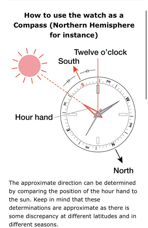 ~~~~~~~~~~~~~~~~~~~ The price of liberty and even of common humanity is eternal vigilance | |||
|
| Member |
When thrashing around in the brush, I always have a Garmin hand held GPS, spare batteries and a Silva compass. Map, too, if I am going any real distance. I wear a Garmin Instinct too sometimes. But I dont think I want to rely on it for critical navigation. End of Earth: 2 Miles Upper Peninsula: 4 Miles | |||
|
| Banned |
I went thru the Infantry School in 1984. No GPS, just a lensatic and a map. When I was reflecting on how the country was explored "in the day" the newest technology was the compass, and those folks were drawing the map as they went along. Real pioneering, not what we do now. Break a leg, you hiked out with it - there was nobody to rescue you. That frame of mind and being raised by others who also had learned and respected the out of doors is quite different from the current attitude - I would say it's the difference between carrying a defensive firearm to protect yourself from bears vs a can of spray. While there were a very few "mountain men" and still are, most pioneers were still living off the land, which was by all reports rich in game. There were no hunting seasons, most travel then was along waterways and that is what you had to drink. Not much in the way of filters either. You navigated by sun, season, and stars - a lot of it was verbal and if there was any sort of pictorial representation of the lay of the land it was both rare and somewhat unreliable, too. Most people would travel in groups - humans normally are social congregants - and shared good and bad. Now we return to the "wilderness" to avoid people. We get out to get away from them. As for GPS - go ask vets of Desert Storm I what they had to put up with. The system was in its infancy in the service and it's characteristics and equipment were still "emerging" from the compass and maps days. I heard a lot of stories where a column was driving in a straight line to a distant landmark and the GPS showed them traveling at right angles away from it. There were reports of large " anomalies" distorting readings. I've come to the conclusion there may well have been compromises and deliberate interference - it's a known topic now to disturb GPS for strategic or tactical purposes. It's not real hard to dupe a signal at a higher wattage and create errors. Those satellites are way up there and I read one comparison to them as "as powerful as a set of high beam headlights - 100 miles away." I'm still hunting and take a Silva Ranger and map, but I also take my cell phone and use Maps to double check my assumptions. Of course, this is in MO and a lot of this side of state sees things cross fenced every acre, it seems. What got my attention was the Suunto Core and having dived down that rabbit hole I've decided I'm doing just fine with the compass, map, a timepiece, and observing the changes in the weather. I don't think ABC watches have "arrived" yet and adding GPS isn't necessarily a reliable source. Charging a device daily is in and of itself a weak link in the system. | |||
|
| Savor the limelight |
TL;DR - RTM (read the manual) None of what was written is a limitation of these watches. A thermometer measures the temperature what it's stuck into or attached to. A compass does not point to true north in most places. An altimeter has to be adjusted to current conditions because the thing it measures varies based on weather, temperature, and get this, altitude. Who knew? I can't see how anyone could get into more trouble because they didn't understand how their watch worked. Seriously, I looked at my watch this morning and it said I was 215' below sea level. If it were true, that would be a real problem since my house is 7' above sea level. I mean, it's not like I'm going to suddenly realize I'm in the eye of a Cat 5 hurricane because my watch says the barometric pressure is 895 millibars. If you are sitting there with a map, compass, and don't know the difference between magnetic north and true north, that is not a problem with the compass (built into the watch or not). I can't really think of a situation where a person would look at the altimeter on a watch and get into any trouble, let alone more trouble. I can't imagine one of our forum pilots sitting in his pressurized cockpit wondering why the altimeter on his watch doesn't match the one on the plane. People who plan to use these tools know how they work and will ask the appropriate question: how do I make the adjustments? The answer, of course, is in the manual. Admittedly, I did not remember 6th grade science when I bought my watch, so I had to read up a bit on the altimeter. That's on me, not the watch. I understood mag north vs true north from sailing, but never really had call to use an altimeter. If your altitude changes a lot while sailing, you have other problems. I do remember my dad adjusting the altimeter in his plane to match what was listed on the chart. | |||
|
| Banned |
Good points being made - yet the issue I read from owner's themselves - in vendor reviews - is that 1) they don't read the manuals and 2) even the manuals don't explain some of the finesse. I was brought up to speed on the PMSL issue by an owner who proceeded to explain it. Which also explained two or three other postings in that review listing from owners who complained bitterly about the altitude inaccuracy - standing on the summit didn't match the height listed on the map. If the local barometric pressure is an artifical mean sea level number, yet at the trail head they are 5,000 feet up, I can understand. Don't plug in the local weather station's number, it's wrong in absolute terms. They use a calculated fudge number which relates to all the other locations in the state, which are all fudge number for meteorological calculations. Not absolute altitude. No, they really just don't know. They complain, send it in for service, get it back, find their expectations are destroyed again, and sell it off. This may go thru a cycle of buying and selling until the light goes on. It happens the same with other products. I bumped into it with folks buying a Bushnell Backtrack, which is a simple GPS. You can log your cars parking spot at the worlds largest mall, and when you are finished, it will show you which way to go to get back. (I now wonder why I'm selling it when I can't find my car at Wally World. Short term memory isn't forever.) The owners wanted INSTANT on with no delay - impossible with sats up in the sky and the calculation needed from three simultaneously. Indoors under the bar joist roofing. With no signal. There was a drastic misunderstanding of how GPS works and why their expectations would not and could not be met. Now add they also wanted to fix it by leaving it on 24/7 so that it would always know exactly where they were to cancel the delay in an answer, and discovered they needed to connect it to a generator to get that result. Even if it was a 100 watt. Which, of course, means taking a can of gas with you . . . Again, expectations by consumers are sometimes physically impossible, they haven't been exposed to those considerations and react with demands that can't realistically be met. Looking at the back of a lot of used Suunto Cores, I don't find evidence they can turn a quarter competently, either. Those use a replacable 2032, and it appears frequently on hikes with some items constantly on, compass being the worst power consumer. Goes to the basics of land navigation - pick a terrain feature and walk to it, then look at the compass. Nope, they want it constant on to check it at any time. A Silva magnetic, sure. An electronic - not so much. Take a stack of batteries - and you know, those are actually sold to do it. An even dozen at a time. GPS are even worse, with power consumption rated in hours. Prepare in advance when your trip is measured in days resembling weeks. Ten day trip? You need eleven recharges. Add that to the packing list, and ultralight with a solar cell stretched over the top of your back, or a major battery recharging pack starts shoving essentials off the table. Compass and a map are much lighter and more reliable. Those that have, know, it's the new users who may need to experience reality who are disappointed their unfounded expectations are shattered. Reading the "Best of" reviews wont inform them, it will only promote a purchase. Not their problem, it's a paid endorsement. That leaves the hiking support community to inform and while people log in to get sage advice from knowledgeable users, they want their expectations upheld. Not reality. Like Goretex - its great when new, don't ask someone hiking thru Ft Dix in a February downpour with an original 8 years old what they suffer. (That jacket hit the road as quickly as I could arrange.) But Goretex is wonderful some say. Not always and certainly not worn out, either. I now avoid it other than new issue. Picked up a MC new current issue shell for $12. At least I know what I'm getting into - no liner. Yes, some people thought a liner alone was suitable for 25F in the day. We get too soon old and too late smart. | |||
|
Member |
Something that happened yesterday illustrates high reliance on electronics versus common sense and knowledge. We were snowshoeing in the Utah backcountry with my brother in law who knows the area quite well. Came across two skiers looking for a specific road. My BIL pointed them in the right direction. However, they were using Google maps which pointed them in the wrong direction (by 180 degrees). They told my BIL "thanks but we will go our own way". They were headed in a direction that would bring them out about 3 miles from their intended destination on a road that will lead back to their car but hiking with skis and tele boots will not be fun. Contour maps, a compass and a clue would have saved them a boring hike. Let me help you out. Which way did you come in? | |||
|
| Semper Fi - 1775 |
And possibly their lives. Of the 7 Deadly Sins, I’ve always believed that Pride is likely the #1 killer. ___________________________ All it takes...is all you got. ____________________________ For those who have fought for it, Freedom has a flavor the protected will never know ΜΟΛΩΝ ΛΑΒΕ | |||
|
| Banned |
Google Maps is not a reliable source. Their road markings aren't actual, but virtual. I live on a dead end lane - yet Maps has an intersection with another road right in front of my house that doesn't exist. And I get a lot of traffic by folks who refuse to see the sign with arrow directing them the correct way. Nope, the blindly follow Maps, not what the residents are trying to communicate. They all back and turn in my driveway if they didn't slow down soon enough. Otherwise they have to either do it in my neighbor's drive. I've seen this for over 20 years, and submitted correction twice to Google, but a new sat photo will erase it and it's back to naive consumers trusting an unreliable source. Not that Rand McNally represents road junctions well, either, I've gotten bit when their pictorial (cartoonish?) map connections are 90 degrees off. Then Maps on the cell has given us a quick answer, not that paying attention to road signs didn't help. Contour line maps are a much better source of info especially on foot. I've found old maps of a local hunting area from the days when it was a military reservation far more accurate, even 70 years old, than the junk published by our Conservation department. If I hadn't hunted on the land for over 45 years there would be no way to find certain landmarks - old dams in a shallow valley, or a small pond that isn't indicated. A geodesic will show it. Yes, two skiers with just a cell phone and Google Maps going 180 degrees out of their way? Unfortunately, there is a story like that every year. How many just hike off down the Grand Canyon trails with 1 water bottle not realizing its four hours up for every hour down? They have helicopter rescue for that, it's not cheap. We last hiked a trail there a week before the 4th of July. The eastern Pacific visitors were geared up for rough terrain hiking, the Middle Easterners were in office wear. The first, small backpacks and water. The second, dress shoes. As humans if we can survive our naivete, then we can safely enjoy the outdoors. I plan some small hikes near Gatlinburg maybe next fall. Compass and map are primary. | |||
|
| Powered by Social Strata |
| Please Wait. Your request is being processed... |
© SIGforum 2025