SIGforum.com  Main Page The Lounge Device for navigation and route tracing when phone GPS not available
The Lounge Page 1 2
Go | New | Find | Notify | Tools | Reply |
Member |
There are times when my cell phone doesn't have service for GPS. This includes times when I'm on road but especially now that I have a truck and can leave the pavement. Is there a device (Garmin?) that can help both on road and especially off pavement? Need something that will help navigate to a destination but also perhaps help me trace back my route if there are no roads/trails on the map - basically let me follow the route I used coming in (back track). I keep forgetting to buy this. Would like to buy one before the next trip out. Also need to buy something that will let me call for help if cell phones don't work. Another Garmin device? Finally, is Bubba rope still good to go as a recovery rope? Need to buy one as well. Hoping to take a trip this fall.... "Wrong does not cease to be wrong because the majority share in it." L.Tolstoy "A government is just a body of people, usually, notably, ungoverned." Shepherd Book | ||
|
Member |
I use a tablet with the Gaia GPS app. It has the advantage of being "friendly" to older eyes, you can download maps for offline use, you can upload tracks, you can drop a "breadcrumb" track, and more. I've never paid for the subscription, as the free seemed to meet all my [cheapskate] needs. Thus the metric system did not really catch on in the States, unless you count the increasing popularity of the nine-millimeter bullet. - Dave Barry "Never go through life saying 'I should have'..." - quote from the 9/11 Boatlift Story (thanks, sdy for posting it) | |||
|
Nosce te ipsum |
My old-school Garmin works off the satellites. I have not used it lately but it is annoying when I'm on phone-gps in the middle of the desert, wonder if a barely-marked side road connects the dots, and the backup is not handy. It's aways 2' away on these cross-country romps but never gets plugged in. https://en.wikipedia.org/wiki/...te_navigation_device | |||
|
Member |
I have used a Qstarz 818XT for years. Android: Install Bluetooth GPS App on a phone or non-phone tablet and download google maps for the area. Connecting the Qstarz GPS receiver to a phone requires enabling Developer Mode and then enabling "Mock GPS Provider" on your device. This is not difficult. | |||
|
The One True IcePick |
GPS doesn't require service to work, it does require semi-unobstructed view of the sky to lock on to 3 more signals. and you will want an app with maps pre-downloaded to the cell phones storage. Garmin makes handhelds that I am sure have better GPS antennas then cell phones. https://www.garmin.com/en-US/c...handheld-hiking-gps/ They also make units that include satellite based communications. Some of those are only 2 way SOS text, I am not sure if they have ones with voice and or standard texting. https://www.garmin.com/en-US/c...llite-communicators/ If you want voice service. - warning anything that involves 2 way satellite communication can get spendy. https://satellitephonestore.co...ale/satellite-phones | |||
|
| Dances With Tornados |
I’d rent a satellite phone before I’d buy one. IOW’s rent one as needed. Lower cost, always updated, etc. Have fun in your adventures. . | |||
|
| Void Where Prohibited |
Do current consumer GPS devices still determine location directly from satellites? I thought I had read a while back that they had switched to using cell tower connections, in which case you would have a problem far away from populated areas. "If Gun Control worked, Chicago would look like Mayberry, not Thunderdome" - Cam Edwards | |||
|
Nullus Anxietas |
I think what you mean by this is when you have no cellular service so your phone can't get updated map segments for where you are/where your're going? I don't know about on-road, but, for off-road use, what I used to use when I had Android devices was BackCountry Navigator It's kind of spendy for a mobile app, at $15, but it works well. Thing is: You have to know where you're going and pre-load the appropriate topo map segments beforehand. And, IIRC, the UI is a bit tricky. (This is one of the apps to which I was referring in my thread about Apple's latest shenanigans.) For on-road... IIRC, again: back when we still used Android devices, Google maps would also let you pre-load map segments? ISTR using that feature when we were going through an area of Canada in which we would not have cell coverage. (That was a strange experience. I'd per-loaded segments for the route we planned to take, but then we deviated from that route. [I recall not why.] Once you started leaving the areas you pre-loaded you headed off into gray areas with no map features.) "America is at that awkward stage. It's too late to work within the system,,,, but too early to shoot the bastards." -- Claire Wolfe "If we let things terrify us, life will not be worth living." -- Seneca the Younger, Roman Stoic philosopher | |||
|
| Member |
I have been surprised how many backcountry Jeep trails are in the Garmin car GPS units. At times my GPS does seem to have a difficult time navigating on these trails. I suspect the position error and map inaccuracy combined are confusing. I have Avenza on an iPad mini. They offer all sorts of nice looking maps. My experience hasn’t been as smooth as I’d expect using an Apple device. My first map download required tech support. Probably my fault. The map didn’t seem to move along with my progress, I don’t have a mount, and I really don’t care to spend my time fiddling with things that should just work. I do plan to give it another try next trip to Colorado and Utah. “That’s what.” - She | |||
|
The Unmanned Writer |
my lick n stick [to the window] Garmin does just that when the "snail trail" option turned on. Life moves pretty fast. If you don't stop and look around once in a while, you could miss it. "If dogs don't go to Heaven, I want to go where they go" Will Rogers The definition of the words we used, carry a meaning of their own... | |||
|
אַרְיֵה |
Every GPS device that I know of, does use satellites. I believe that Apple location service uses cell towers, not sure about Android. הרחפת שלי מלאה בצלופחים | |||
|
| Member |
You don't need cell service for your phone's GPS to work. Your issue is that your map of the area isn't downloaded or cached for offline use. If you want to continue using your phone for its GPS capabilities when you have no cell/data reception, there are several apps such as Gaia GPS that allow you to download maps for offline use. | |||
|
Member |
Paper map, if you can find any or gps. Android uses cell towers. . | |||
|
| Raised Hands Surround Us Three Nails To Protect Us  |
This is 100% the way to go. Gaia does have a bit of a learning curve but is very very good. I bought an inexpensive Samsung Galaxy tablet at Costco and this is my dedicated off-road GPS. Check the specs of the tablet as not all tablets have GPS capabilities. Sure predownloading maps for use with nonGPS devices work 99% of the time but that 1% can get you in a real hot mess if you don’t have real time GPS and you come to an issue on the trail when you have no service. GPS enabled tablets are inexpensive enough. I run the Agama car launcher on the tablet to make the Home Screen much more manageable compared to a bunch of tiny Icons. I also run my OBDII monitoring software on it so I can monitor my vehicles real time sensors while off-road. 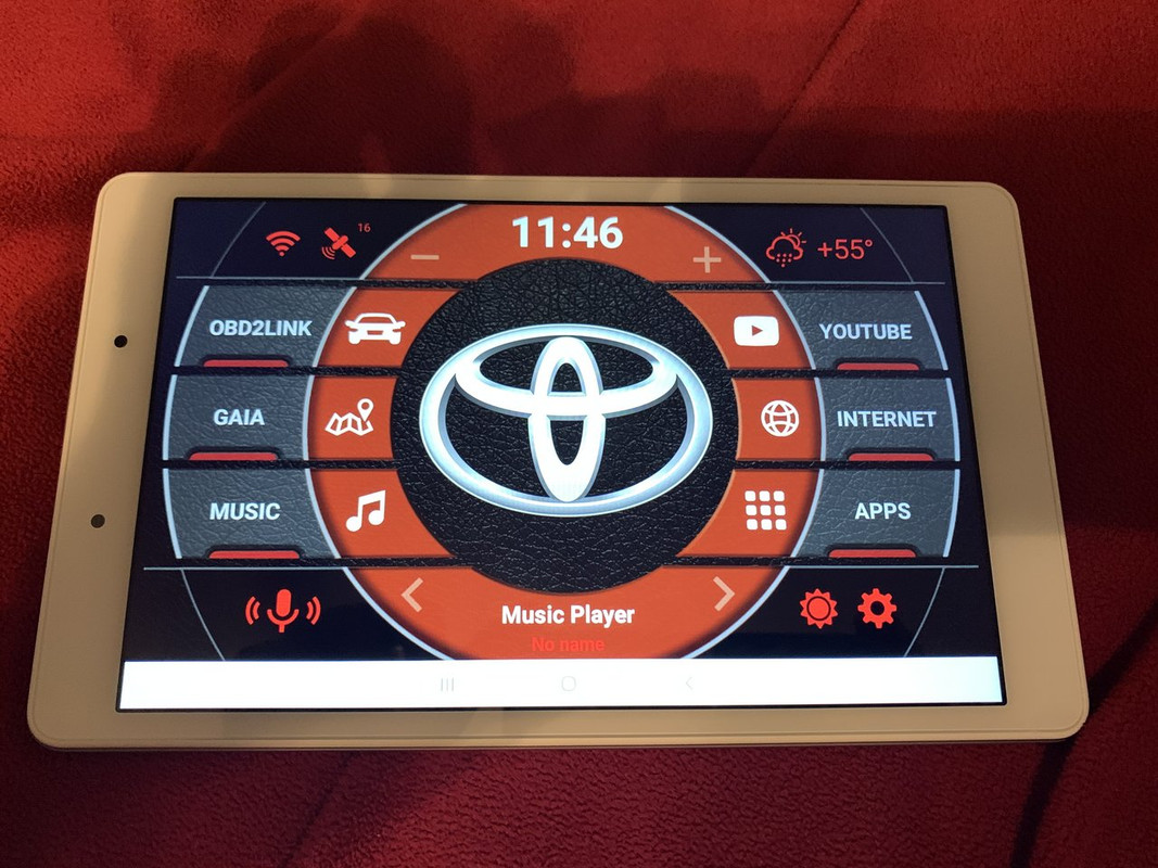 If you have an old iPad or iPhone you can buy a Bad Elf GPS adapter and give it full GPS access. https://bad-elf.com/pages/be-gps-1008-detail For your emergency call stuff a Spot seems to be very popular. I don’t have one yet but plan to eventually. https://www.findmespot.com/en-...s-services/spot-gen4 Bubba’s are really good but come at a price. An ARB Snatch strap is like $65 and will handle plenty for a casual off-roader ARB 4x4 Accessories ARB705LB Orange 30' x 2 3/8" Snatch Strap Recovery, 1 Pack https://smile.amazon.com/dp/B0..._encoding=UTF8&psc=1 Do you have recovery boards?? The ARB snatch strap and a set of decent recovery boards will run a little cheaper than the Bubba or comparable kinetic rope. ———————————————— The world's not perfect, but it's not that bad. If we got each other, and that's all we have. I will be your brother, and I'll hold your hand. You should know I'll be there for you! | |||
|
Member |
Maps.me in the app store. Offline maps. Work when you have no service. You download the ones you want/need and you're all set. https://maps.me/ | |||
|
Political Cynic |
Buy yourself a Gazetteer | |||
|
| Member |
I made some assumptions in my initial recommendation. Black92LX clarified a number of them. 1. OP's device may or may not have GPS. My assumption is that what he really means is that he can't download maps when off-grid. If it really doesn't have GPS, or if he wants a larger screen, he can get an inexpensive tablet, as Black92LX suggests. 2. OP's intention is to use the device in off-road, off-grid, back-of-beyond applications. (Black92LX has additional preparation tips for that scenario.) 3. OP wants bread crumbs. This limits choices to electronic, not paper. 4. Paper is good. I always have paper with me (DeLorme, USGS, others). And I know how to use it. But nothing beats the convenience of electronic. 5. A dedicated device (e.g., Garmin GPS) isn't really necessary. They also have the disadvantage of having a small screen. (Old guy tip!) I missed the "call for help" part. I used a SPOT. It was pretty basic, but it was also the most cost effective of the options out there. Options were pre-planned messages. One was SOS (can't customize). The other two I had set to "emergency but not time critical", and "I'm OK". DeLorme InReach was next, has satellite texting capabilities (i.e., custom messages). Sat Phone was most costly. There may be other options now. Thus the metric system did not really catch on in the States, unless you count the increasing popularity of the nine-millimeter bullet. - Dave Barry "Never go through life saying 'I should have'..." - quote from the 9/11 Boatlift Story (thanks, sdy for posting it) | |||
|
| Member |
any decent mobile GPS will do what you want. You can get any screen size you want to the size comment. I'm a Garmin guy, but its because I have used them for so many years that I can figure out what exactly the idiots that program them were thinking. You want help outside cell you want a sat phone. Spot really sucks in terms of anything but a full on rescue mission. “So in war, the way is to avoid what is strong, and strike at what is weak.” | |||
|
Member |
I would suggest an OnX subscription for your phone (they even have one for off roading) and download the maps before you go... as has been said your phone GPS will work without cellular signal but you need to pre download the map to see. Then look at the Garmin InReach mini. It allows for two way text communications and SOS in the event of a real emergency. Subscription of course but depending on how much you text it is very reasonable. Different use but I spend many days at a time in remote mountain country, alone, with this set up... it works well and provides peace of mind to myself and family knowing that I can get the Calvary coming if necessary, check in with home, and they can reach me if there is an emergency in town. ----------------------------------- | |||
|
Member |
One of the Garmin Inreach devices might work for you. There are models with GPS mapping as well as satellite text messaging capabilities that could be used to send status reports or call for assistance (for monthly fees). "Cedat Fortuna Peritis" | |||
|
| Powered by Social Strata | Page 1 2 |
| Please Wait. Your request is being processed... |
SIGforum.com Main Page The Lounge Device for navigation and route tracing when phone GPS not available
The Lounge © SIGforum 2026