December 21, 2019, 09:34 PM
2000Z-71Denali Park Road Landslide
Feeling very lucky that we won a spot in this years's Denali Riad Lottery and were able to drive to the end of the road in the park. They announced a few days ago that the road may not open past mile marker 43 this coming year due to a slow motion landslide. More detailed report on the US Park Service website today. Since we drove the road in September and now, a section of road has slid down the road by 11'. Welcome to Alaska and its weird and wonderful geology. Definitely check out the link for pics.https://www.nps.gov/dena/learn...jApbkcbb0aEnyOxcWcBo
Winter Season: Road Open to Mile 3 (Park Headquarters)
The Denali Park Road is currently open to Mile 3, Park Headquarters. Wintry conditions beyond that point prevent vehicle travel, though pedestrian travel is permitted. The Winter Visitor Center is open daily, 9:30 am - 5 pm, at Mile 1.5.
1 more non-emergency alert notifications...
NPS.govPark HomeLearn About the ParkNatureGeologyPretty Rocks Landslide
Pretty Rocks Landslide
Learn and Explore
A section of the Denali Park Road, called Pretty Rocks, traverses a precipitous slope high on the side of Polychrome Mountain. Built in the 1920s and 1930s as a scenic high route, this section of the road is at roughly the mid-way point on the 92-mile long road. The Pretty Rocks Landslide at Mile 45.5 of the park is one of several known landslides in that general area and one of the more than 140 mapped “unstable slopes” along the entire park road. Aerial surveys and monitoring on-site this winter revealed that the speed of the slide has increased dramatically since September 2019.
The Pretty Rocks Landslide has the potential to greatly disrupt transportation, negatively impact visitor experience, curtail commercial services and affect public safety. Park managers are working to evaluate geologic data and potential engineering solutions to implement plans to keep the road operational, resilient and safe for travel under dynamic and changing conditions. Travel restrictions will sometimes be necessary.
ON THIS PAGE:
What Visitors Should Know
Comparison Photo
Background Details About the Landslide
Why the Park Road Traverses Polychrome
a man standing on a dirt road that has cracked and dropped well over seven feet
Park geologist Denny Capps at Pretty Rocks in December, 2019. The landslide speed has increased significantly in fall 2019, and has now fallen from grade by 11 feet since September, 2019.
NPS Photo
What Visitors Should Know
Section last updated: December 17, 2019
Travel Restrictions Are Possible
It is probable that access beyond Pretty Rocks (Mile 45) will be affected throughout the season. This could mean periodic road closures to all traffic, with traffic likely stopping at the East Fork of the Toklat (approximately Mile 43), as that is the safest spot to turn vehicles around before the road begins climbing Polychrome Mountain, or possibly stopping at Teklanika River Rest Stop (Mile 30), as that is the nearest turnaround with restrooms.
At this time, park managers anticipate that the road may only open to Mile 43 on May 20, 2020, rather than to Toklat RIver (Mile 53), which is the normal distance the road opens each year on May 20.
The park continues to collaborate with the Federal Highways Administration for technical assistance on short and long term plans to address the Pretty Rocks Landslide issue. Additionally, the park is working on an interim visitor services plan.
Cyclists riding the Denali Park Road will not be able to detour around Pretty Rocks, and so travel restrictions will likely apply to them as well.
Check this page periodically for more information on impacts to bus services, Wonder Lake campground and other visitor services, or read the latest press release on this topic.
Bus Schedules Might Change
Visitors might find that bus service in the park is significantly limited compared to previous years. This might only affect the first few weeks of the season (from May 20 onward); it might only be periodic throughout the season; or it might last the entire summer.
Hiking and Backpacking May Be More Complex
Hikers and backpackers should plan to spend extra time in advance of a big hike or backpacking trip talking with rangers at the Denali Visitor Center. Areas of the park farther west than Pretty Rocks will not be closed, but it may take longer for hikers to reach those backpacking units if bus service is limited. Trails around the Denali Visitor Center, at Mile 1.5 of the road, will not be affected.
Wonder Lake Campground May Not Open on Time
Wonder Lake Campground (Mile 85) normally opens on June 8 each summer. The opening date may be pushed back, or the campground may be closed periodically, or for the entire summer, depending on the nature of the road work at Pretty Rocks.
PRETTY ROCKS LANDSLIDE COMPARISON (SEPTEMBER 2018 VS APRIL 2019)
woman and child sitting on a dirt road with a large crack in the middle of ita woman standing on a dirt road, on a section that has cracked off and slumped below the main roadbed
The eastern landslide scarp through the road on September 29, 2018. The road was last graded on September 14th and closed to most vehicle traffic on September 19th. The photo below was taken six months later in the same location. NPS Photo
The eastern landslide scarp through the road on 3/22/2019. Survey rod held by park employee is 6.5 feet (2.0 m) tall and is placed near center-line of the road. Note employees had recently shoveled dirty snow in foreground to aid in measuring the scarp. NPS Photo
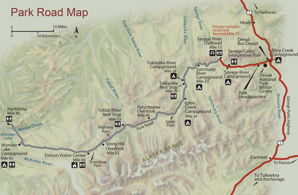
a map of denali illustrating its location in central alaska. a red mark indicates the location of pretty rocks, in roughly the middle of the park's sole road
Shaded-relief map of Denali National Park and Preserve outlined in green. Black line is the Denali Park Road, red asterisk indicates location of the Pretty Rocks Landslide. Red line is the George Parks Highway. Inset map shows location of the park (green line) in Alaska.
Detailed Background
Over the last nine decades (the road was constructed in 1930), the Pretty Rocks Landslide has evolved from a minor maintenance concern to an existential threat to the current visitation model.
During the 1990s, maintenance sta&#ff
aerial image of a dirt road on a precipitous mountainside with a line circling an area indicating a landslide section
Oblique view of the Pretty Rocks Landslide. Background is a composite image from June 15, 2015 with the approximate landslide outline indicated by red dots.
NPS Image
Options to Improve Resiliency or Relocate the Road
Existing Road Alignment Across Polychrome Pass
Several options exist to mitigate the risks at Pretty Rocks within the existing road corridor. While there are challenging locations, most of the problematic areas are known. Consideration of risks (safety, construction, maintenance, etc.) posed by all landslides in this section of road is critical when choosing the most appropriate option as even small realignments may be unfeasible.
Popular visitor destinations including Polychrome Overlook are in areas adjacent to the Pretty Rocks Landslide. Farther west along the road, visitors can access Stoney Overlook and the Eielson Visitor Center. The State of Alaska (through the State Historic Preservation Office) and the National Park Service recognize the current road alignment as a historic resource worth protecting and have nominated the Mount McKinley National Park Road Historic District for listing in the National Register of Historic Places.
There were four basic in-place design options identified for further analysis. Each had potential to sufficiently improve safety and resiliency at the Pretty Rocks Landslide without significantly rerouting the road. Two were determined to no longer be feasible:
Resist: build engineered structures to arrest landslide movement
Tunnel: build a tunnel in bedrock behind landslide
The two other options remain viable:
Earthwork: remove rock, debris, and ice until risk adequately reduced
Bridge: build a bridge over the landslide
As described below, two options to move this section of road away from the hazard are being developed. A road terminus option is also being developed.
South Reroute Option
A south reroute (see Fig. 3) would depart the existing alignment near the East Fork River (Mile 43), broadly paralleling the existing road to the south, and rejoin the road near Mile 48. There is relatively high confidence in understanding the risk of constructing a roadway here. Most importantly this area has much lower topography, which decreases the chance of landslides and eases road constructability. A gravel road would be constructed on upland areas and bridge numerous and wide floodplains. While the upland areas have relatively low topography, it likely contains a high amount of thaw-unstable permafrost. Permafrost is thawing regionally. Through monitoring, it has been demonstrated that disturbing thaw-unstable permafrost for the construction of infrastructure causes negative subsequent impacts to infrastructure and natural and cultural resources. Therefore, the upland road sections may be easy to construct, but will involve greater maintenance needs due to the underlying permafrost.
NPS Management Policies (2006, Subsection 4.6.4 – Floodplains) states that we must:
Protect, preserve, and restore the natural resources and functions of floodplains
Avoid the . . . environmental effects associated with the occupancy and modification of floodplains
Avoid direct and indirect support of floodplain development that could adversely affect the natural resources
When it is not practicable to locate or relocate development or inappropriate human activities to a site outside and not affecting the floodplain, the Service will . . . use non-structural measures as much as practicable to reduce hazards to human life and property, while minimizing the impact to the natural resources of floodplains
As a result, floodplains would likely need to be bridged. While this presents a lesser engineering challenge, bridges are expensive, particularly in this remote environment.
Upland Reroute Option
Similar to the proposed South Reroute, an upland reroute would depart the existing alignment near the East Fork River (Mile 43), broadly parallel it to the north, and rejoin the road near Mile 48 (see Fig. 3). There is relatively low confidence in understanding the risk of constructing a roadway here. This option must either be substantially longer or cross even more topography than the existing road corridor. Similar geotechnical challenges are expected along this reroute compared to the existing route because it has similar geology, several known landslides, and likely contains abundant thaw-unstable permafrost. Additionally, several hundred-thousand to a few-million cubic yards of gravel would be needed to construct this reroute; reserves of that magnitude are not identified. Gravel sources outside the park would be prohibitively expensive and hauling would create adverse effects on the road. As a result, this option will continue to be investigated, but it has limited feasibility.
Road Terminus at Mile 43
Ending the Road near the East Fork River (Mile 43; see Fig. 3) is another alternative. This option is not preferable because it would have substantial impacts to tourism (and therefore the regional economy), including loss of overland access to the Toklat River Rest Stop, Eielson Visitor Center, the Wonder Lake Campground, in-holder properties (private property and commercial businesses) in Kantishna, other important infrastructure and cultural and natural resources. The park would need to construct an appropriate turnaround and facilities near the East Fork River. As a result the park and stakeholders would need to significantly modify visitation patterns. Such a step would likely lead to higher impacts to resources within the shortened road corridor.
Cost Estimates
We have only begun to calculate reliable cost estimates for the above-proposed alternatives. The Federal Highways Administration expects to generate preliminary cost estimates by the first quarter of 2020 once permafrost and engineering data become available.
relief map of a mountain. color overlays indicate possible new routes for a road, on the north side of a mountain and on the south side. third area indicates a possible turn-around location for the park road.
Figure 3. Image depicts two possible reroute corridors and one possible road terminus.
Next Steps
The following are the next steps the NPS and FHWA are taking to address this important issue:
Complete plans for reestablishing and maintaining the road in 2020, if possible
Reinstall near-real-time monitoring system within the landslide that allows rapid detection and response to changes in landslide velocity
Continue review and analysis of proposed bridge and earthwork options
Complete memo on reconnaissance-level surface investigations of all proposed reroute areas
Collaborate with academic partners to monitor permafrost and its impacts on the location, mechanism, magnitude, and timing of landslide events along all potential routes
Continue quarterly Reports to Congress
History of the "High Line"
The Alaska Road Commission (ARC) began to build the trans-park road into Mount McKinley National Park in 1922. Over the course of 16 years, crews carved a road out of wilderness. During this time, the National Park Service decided to place part of the road along the side of Polychrome Mountain—the "High Line."