The large island due West of the storm is Freeport
Geography 101: The island west of the storm is Grand Bahama. Freeport is one of the cities on Grand Bahama Island.
Technically correct, yet nobody calls it Grand Bahama, including the people that live on it. I go there a few times a year as 1 customer of mine loves Port Lucaya.
September 01, 2019, 06:06 PM
smithnsig
quote:
Originally posted by jimmy123x:
quote:
Originally posted by RHINOWSO:
quote:
Originally posted by trapper189:
quote:
It is, 180 MPH winds are unheard of.
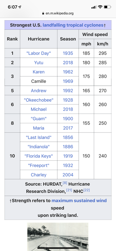
Oh please. Wilma-185, Rita-180, Gilbert-185, Labor Day 1935-185, Allen-190, Mitch-180, Irma-180 and now Dorian.
It's just more of the "Climate Drama" tags lines.
The first Category 5 in history to make landfall was Hurricane Michael in 2016 since the one in 1935 "labor day hurricane". None of the ones listed above made landfall with anything close to a category 5. Wilma was 125 MPH winds CAT2/possible weak 3 when it hit North Miami, I know as it landed 20 miles from my house and I was without power for 21 days. Irma made landfall as a weak Category 1 at 85 mph winds +/- when it hit and that landed 100 miles South of me and I was without power 14 days.
There are very very very few structures that can withstand Dorian's 185 MPH winds and gusts over 200 MPH. The hurricanes listed above never made landfall (besides Michael) at anywhere close to a 5.
There's just no way of even fathoming 185 mph winds and their damage. We're talking Andrew + with the reach of Sandy+.
The butcher with the sharpest knife has the warmest heart.
September 01, 2019, 06:17 PM
V-Tail
quote:
Originally posted by jimmy123x:
quote:
Originally posted by V-Tail:
quote:
Originally posted by jimmy123x:
The large island due West of the storm is Freeport
Geography 101: The island west of the storm is Grand Bahama. Freeport is one of the cities on Grand Bahama Island.
Technically correct, yet nobody calls it Grand Bahama, including the people that live on it. I go there a few times a year as 1 customer of mine loves Port Lucaya.
In simple words: Bullshit!
הרחפת שלי מלאה בצלופחים
September 01, 2019, 06:33 PM
ZSMICHAEL
Thanks for mentioning Camille, which came ashore in Pass Christian, MS. in August of 1969. Even though it was a Category 5 at landfall, Katrina which made landfall as a Category 3 had a 28 foot storm surge, because it was a much larger storm.
There is a local saying here that Camille killed more people in 2005. People figured that if they were not affected by the storm surge in Camille, that they would be fine.
September 01, 2019, 06:52 PM
jimmy123x
quote:
Originally posted by V-Tail:
quote:
Originally posted by jimmy123x:
quote:
Originally posted by V-Tail:
quote:
Originally posted by jimmy123x:
The large island due West of the storm is Freeport
Geography 101: The island west of the storm is Grand Bahama. Freeport is one of the cities on Grand Bahama Island.
Technically correct, yet nobody calls it Grand Bahama, including the people that live on it. I go there a few times a year as 1 customer of mine loves Port Lucaya.
In simple words: Bullshit!
It's the truth. Everyone simply calls it Freeport......since the city pretty much encompasses the island. Just like everyone refers to the Florida Keys as the keys......I'm going to the keys this weekend...…..Nobody EVER refers to Nassau as New Providence, considering New Providence is the island and Nassau is the town. They simply say, I'm going to Nassau because the city of Nassau pretty much encompases the entire island now.
September 01, 2019, 07:00 PM
parabellum
OK guys
September 01, 2019, 10:30 PM
ensigmatic
Dorian's now slowed to 5 MPH and still a Cat 5 with winds of 177 MPH, gusting to 225. It damn well better make that turn to the north.
"America is at that awkward stage. It's too late to work within the system,,,, but too early to shoot the bastards." -- Claire Wolfe "If we let things terrify us, life will not be worth living." -- Seneca the Younger, Roman Stoic philosopher
September 01, 2019, 11:33 PM
Dakor
quote:
Originally posted by ensigmatic: It damn well better make that turn to the north.
If it doesn’t, it’s going to be one of the biggest clusterfucks in the history of meteorology. I don’t put much stock in forecasting models with strong storms, as Mother Nature often shrugs.
September 01, 2019, 11:53 PM
jimmy123x
quote:
Originally posted by Dakor:
quote:
Originally posted by ensigmatic: It damn well better make that turn to the north.
If it doesn’t, it’s going to be one of the biggest clusterfucks in the history of meteorology. I don’t put much stock in models as Mother Nature often shrugs.
I keep waiting for it to turn also. It's 30 miles North of my house and going due West. 2 of the models have it turning within 10-20 miles of the coast and following right along or right inside of the coast up to Jacksonville area before heading more out to sea. My gut feeling is it will turn North about 20 miles offshore when it starts feeling resistance from the condo's on the beach, but who knows. The HWRF and HMON models have it going right along the beach or even inland a bit up until Jacksonville in the 12 AM forecast. Once it gets past Freeport and hits the Gulfstream, we'll see if it turns or not. It's going to be a VERY devastating situation if it doesn't turn sooner than later. The Millibars have stayed the same at 925, the last 3 forecasts.
This message has been edited. Last edited by: kimber1911,
“We’re in a situation where we have put together, and you guys did it for our administration…President Obama’s administration before this. We have put together, I think, the most extensive and inclusive voter fraud organization in the history of American politics,” Pres. Select, Joe Biden
“Let’s go, Brandon” Kelli Stavast, 2 Oct. 2021
September 02, 2019, 06:28 AM
maladat
The Current NHC prediction still has Dorian making the turn north, but coming closer to the Florida coast before if does so.
September 02, 2019, 06:32 AM
mojojojo
quote:
Originally posted by jimmy123x: ...when it starts feeling resistance from the condo's on the beach, but who knows.
Please tell me you’re joking
Icarus flew too close to the sun, but at least he flew.
September 02, 2019, 07:24 AM
trapper189
quote:
Originally posted by mojojojo:
quote:
Originally posted by jimmy123x: ...when it starts feeling resistance from the condo's on the beach, but who knows.
Please tell me you’re joking
That's the way he rolls. Just smile and nod.
September 02, 2019, 07:27 AM
Opus Dei
Stay safe, y'all. God be with you.
September 02, 2019, 07:48 AM
ChicagoSigMan
My father's house just went outside the cone by a couple miles in the latest update. Hoping he'll be spared the worst of the storm, but it looks like tropical storm force winds are 90% probability.
September 02, 2019, 10:14 AM
Leemur
It’s been downgraded to a Cat 4 so hopefully it’s a sign that it’ll continue to weaken at a rapid pace. Hopefully.
September 02, 2019, 10:26 AM
valkyrie1
Looks like my parents and cousin are going to get hammered in St.Augustine and Palm Coast.
 This message has been edited. Last edited by: kimber1911,
