September 01, 2019, 10:28 AM
patwTracking Dorian
^^^^The "towers" at the plant can sustain a direct crash from a 747,so the wind should not be a problem. The problem arises due to the support areas of the reactors/towers. Again, should not be a problem with the forecast.
I feel bad for the people in the Bahamas and hope they left for other areas close by, that will not feel the brunt. I can't imagine the devastation as this is the strongest hurricane on record, so says the news.
September 01, 2019, 10:36 AM
trapper189quote:
It is, 180 MPH winds are unheard of.
Oh please. Wilma-185, Rita-180, Gilbert-185, Labor Day 1935-185, Allen-190, Mitch-180, Irma-180 and now Dorian.
September 01, 2019, 02:50 PM
RHINOWSOBut they are far from 'unheard' of, from a planetary perspective.
Now some of us humans enjoy lathering ourselves up in drama, but it's just a very large, dangerous storm.
Like ones that have been happening for thousands upon thousands of years.
September 01, 2019, 03:08 PM
trapper189quote:
Originally posted by jimmy123x:
The first Category 5 in history to make landfall was Hurricane Michael in 2016 since the one in 1935 "labor day hurricane".
Just stop with the sensationalist talk. First in history behind the first in history makes it the second, no?
"180mph winds are unheard of". Nope.
"Irma made landfall as a weak Category 1 at 85 mph winds +/- when it hit and that landed 100 miles South of me and I was without power 14 days." Irma was a lower Cat.4 when it hit Cudjoe Key. It went over Marco Island as a Cat.3.
"The hurricanes listed above never made landfall (besides Michael) at anywhere close to a 5." Neither has Dorian in the USA, has it?
I'm not saying it's not impressive or people shouldn't keep an eye on it.
I'm saying stop with the nonsense hype and untrue "facts". It doesn't help. I'm not any kind of expert on hurricanes which just makes that I recognize the BS you are spewing even worse. I should just let it go like the time my mom's 90 year old aunt told me that Wal-Mart owned Home Depot. Sometimes, I should just smile and nod.

September 01, 2019, 03:36 PM
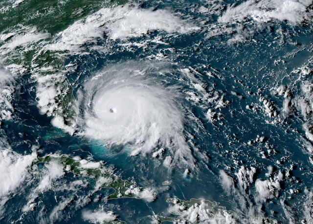
ZSMICHAELHurricane Dorian Tropical Cyclone Update
NWS National Hurricane Center Miami FL AL052019
400 PM EDT Sun Sep 01 2019
...CATASTROPHIC CATEGORY 5 DORIAN POUNDING GREAT ABACO...
This is a life-threatening situation. Residents in the Abacos
should stay in their shelter. Do not venture out into the eye if it
passes over your location.
Hazards:
- Wind Gusts over 220 mph
- Storm Surge 18 to 23 feet above normal tide levels with higher
destructive waves
These hazards will cause extreme destruction in the affected areas
and will continue for several hours.
SUMMARY OF 400 PM EDT...2000 UTC...INFORMATION
----------------------------------------------
LOCATION...26.6N 77.3W
ABOUT 0 MI...0 KM E OF GREAT ABACO ISLAND
MAXIMUM SUSTAINED WINDS...185 MPH...295 KM/H
PRESENT MOVEMENT...W OR 275 DEGREES AT 7 MPH...11 KM/H
MINIMUM CENTRAL PRESSURE...910 MB...26.87 INCHES
$$
Forecaster Blake
That is somewhat impressive. You do not usually see a storm surge of that magnitude. Katrina hold the US record at 28 feet.
September 01, 2019, 04:01 PM
ZSMICHAEL00
WTNT45 KNHC 012056
TCDAT5
Hurricane Dorian Discussion Number 34
NWS National Hurricane Center Miami FL AL052019
500 PM EDT Sun Sep 01 2019
The distinct eye of powerful Hurricane Dorian is moving over
Great Abaco. The latest wind and pressure data from an Air Force
reconnaissance plane just before the eye hit the island indicated
that the winds reached 160 kt, which is the initial intensity for
this advisory. It is not very often that we measure such strong
winds. The minimum pressure measured by the plane was 910 mb.
The eye has been shrinking, and an eyewall replacement cycle is
possibly occurring. The effect of the island terrain and the
eyewall replacement cycle should result in some slight fluctuations
in intensity during the next 24 to 36 hours, but the hurricane will
continue to be extremely dangerous one during that time. After 3
days, a more definite weakening trend should begin as the hurricane
encounters stronger shear. Dorian however, it is forecast to remain
a hurricane for the next 5 days.
Dorian has slowed down even more and is now moving toward the west
or 270 degrees at 4 kt. The steering currents are collapsing and
Dorian is expected to slow down a little more, prolonging its
catastrophic effects in the northwestern Bahamas. The NHC forecast
calls for a slow west to west-northwest motion during the next 48
hours. A turn to the north and northeast with a gradual increase in
forward speed is expected thereafter, as the mid-level trough over
the eastern United States deepens. The current forecast is not very
different from the previous one, and it is very close to the
multi-model consensus TVCA. Both the deterministic and consensus
tracks have shown the usual variability to the right or to the left
from run to run, but the overall trend is for the hurricane to turn
northward offshore but dangerously close to the Florida peninsula.
Given the uncertainty in the track forecast and the anticipated
increase in size of the hurricane, a Hurricane Warning and Storm
Surge Warning have been issued for a portion of the Florida east
coast. It is once again emphasized that although the official track
forecast does not show landfall, users should not focus on the exact
track. A small deviation to the left of the track could bring the
intense core of the hurricane its dangerous winds closer to or onto
the Florida coast.
Key Messages:
1. A prolonged period of catastrophic winds and storm surge will
affect the Abaco Islands and Grand Bahama Island tonight. Everyone
there should take immediate shelter and not venture into the eye.
2. Life-threatening storm surge and dangerous hurricane-force winds
are expected along portions of the Florida east coast through
mid-week, and storm surge and hurricane warnings are in effect. Only
a slight deviation to the left of the official forecast would bring
the core of Dorian near or over the Florida east coast. Residents
should listen to advice given by local emergency officials.
3. There is an increasing likelihood of strong winds and dangerous
storm surge along the coasts of Georgia, South Carolina, North
Carolina later this week. Residents in these areas should continue
to monitor the progress of Dorian and listen to advice given by
local emergency officials.
4. Heavy rains, capable of producing life-threatening flash floods,
are expected over northern portions of the Bahamas and coastal
sections of the southeast and lower mid-Atlantic regions of the
United States through late this week.
FORECAST POSITIONS AND MAX WINDS
INIT 01/2100Z 26.6N 77.3W 160 KT 185 MPH
12H 02/0600Z 26.7N 78.1W 155 KT 180 MPH
24H 02/1800Z 26.8N 78.7W 145 KT 165 MPH
36H 03/0600Z 27.0N 79.0W 135 KT 155 MPH
48H 03/1800Z 27.7N 79.5W 125 KT 145 MPH
72H 04/1800Z 30.0N 80.3W 105 KT 120 MPH
96H 05/1800Z 33.0N 78.5W 90 KT 105 MPH
120H 06/1800Z 36.5N 73.5W 80 KT 90 MPH
$$