August 30, 2019, 11:00 PM
jimmy123xTracking Dorian
quote:
Originally posted by PASig:
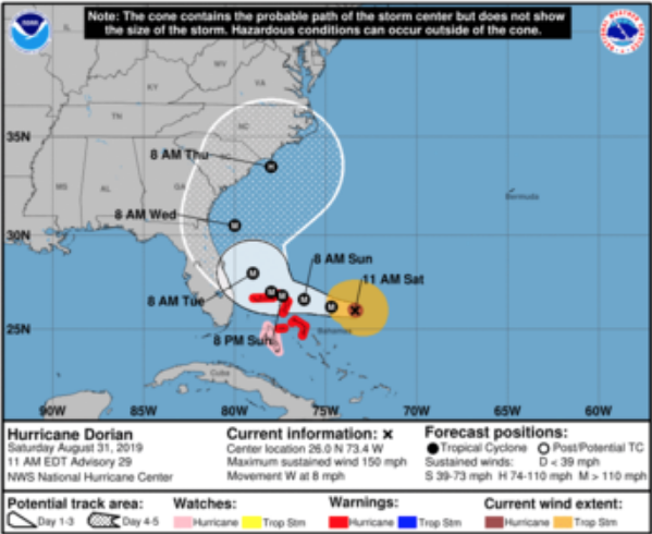
The Weather Channel just showed their 4 most likely storm tracks as of 11:45 pm tonight 8/30/19 and they all seem to hug the coast or stay just off the coast and go up.
That is a very good thing. But look how much of the state is going to have at least Tropical Storm winds
https://www.nhc.noaa.gov/refre...tml?mltoa34#contentsAlso look how far inland CAT 3 or better winds go into the state. It's still going to be very serious damage if it doesn't turn more.
https://www.nhc.noaa.gov/refre...l?tswind120#contentsAugust 31, 2019, 12:00 AM
trapper189quote:
Originally posted by jimmy123x:
Also look how far inland CAT 3 or better winds go into the state. It's still going to be very serious damage if it doesn't turn more.
https://www.nhc.noaa.gov/refre...l?tswind120#contents
I think you linked the wrong graph. The linked graph shows probability of winds greater than 39mph. There's another graph just like it that shows probability percentages of winds over 75mph. Very little of the state has more than a 30% chance.
August 31, 2019, 06:20 AM
jimmy123xThis mornings forecast has it turning North earlier and staying 20-50 miles offshore of Florida, but now shows it hitting SC as a CAT 1 or 2. Hopefully it continues to turn.
August 31, 2019, 07:10 AM
ChicagoSigManBreathing easier this morning. My part of SW FL isn't even in the cone anymore. Looks like some heavy rain and gusty winds might be the worst we get. I'll take it.
Sure would be nice if Dorian stayed offshore as the latest model suggests, although it looks as if South Carolina better start getting ready. Stay safe everyone.
August 31, 2019, 07:38 AM
just1tymThough in the other thread about the trip to Orlando many suggested experiences relating to hurricanes, damages, and category storms. My experience to the lighter references the media made, in this thread possibly making slight off handed comments edging towards category 5 class storms. Having experienced a possible one-time event in my life with the direct impact of Hurricane Andrew in 92' I can tell you it was a living nightmare and still makes me queasy thinking about that experience.
One is that really nobody was really prepared mentally or covered all the preparations for what was to come. We were settling down to rest finally, and woke up to discover it was barreling straight towards my area, and was expected to possibly be a category 5 at landfall, which was only several hours away. As much as I thought we were prepared, we sorely fell short everywhere. As the storm rumbled in on top of us, through the loud roaring you could hear loud bangs, and constant crashing sounds unlike anything you could ever imagine. It was the sounds of the house being ripped apart, gone was the windows, gone were the doors being blown out, gone was sections of the roof, where did the screen patio went that was once here? Then the constant, and I mean constant only letting off for a slight 15 min gap as we were in the very tip of the north of the eye wall passing over, then when that constant roaring and banging and crashing you'd had enough of started peaking again as the other side of the storm cranked up again, the prayers began.
Hurricane Andrew spawned several tornadoes on the edge of the eye wall which were linked to much of the amazing destruction and property damages. Though as the storm raged, you'd never be able to discern those as I was imaging that this is what being inside a tornado sounds like, but for 10-12hrs constant, that really wears you down, not to mention the effect it was having on my pets who were traumatized, so much so that they started to slither around on their belly's like a snake out of just plain fear.
As the wind and rain raged thru the house, we were to spend the rest of our lives in the hall way bathrooms as it seemed, spared only by the small 15min window that it slightly calmed down as the tip of the eye wall passed over. And another thing to add, I never experienced anything like the popping of my ear drums as the barometric pressures plunged during the storm while in a house on the ground. Perhaps this was a major contributor to the dogs behaviors also. Like being at altitude in a plane, only you're in your own home...
I can only hope that this was a once in a lifetime event for me because I'll never go thru another if one is forecasted in my direction, I'll definitely be much further inland in a very secure location...that is all.
Regards, Will G.
August 31, 2019, 08:29 AM
trapper189We learned a lot from Andrew. Building standards are much better now. I rode out Charley in a new at the time home that suffered little damage. The 1960s house next door was destroyed. Early that morning, it was supposed to go Tampa as a Cat.2. In just 3 hours, it went from Cat.2 to an upper Cat.4 and went right up Charlotte Harbor. It was too late to go anywhere by that point.
I keep an eye on any storm heading my way and hold my breath a bit.
August 31, 2019, 08:37 AM
FlyingScotDorian need to keep on truckin’ out to sea. We are prepared for the next one, our family has this scramble down pretty good at this point. If comes to us, all I need to do is strap down AC. Strap down the boats, and take the gate doors off and put in garage.
Only down side of future storms is my 1977 280z will be out of the garage. Decided to put newer / more valuable cars in garage - it is a full restoration project anyway.
This one was scary and still is as a huge CAT4/5. Didn’t really want to test storm windows, roof strapping, etc. they *should* be good up to 160, but let’s hope we never have to find out.
“Forigive your enemy, but remember the bastard’s name.”
-Scottish proverb August 31, 2019, 09:17 AM
Sig2340This a neat image of the tonal scale of the storm's clouds..
It's A Picture of Dorian Gray.
Nice is overrated
"It's every freedom-loving individual's duty to lie to the government."
Airsoftguy, June 29, 2018
August 31, 2019, 10:33 AM
TommydoggThis is a drill, this is a drill! Drill complete restow all gear!
___________________________
"I Get It Now"
Beth Greene
August 31, 2019, 02:07 PM
ChicagoSigMan2PM Update
August 31, 2019, 06:04 PM
jimmy123xThe forecast is looking better and better. But, I've been through so many of these that I'm not breathing easy until Dorian makes it's turn and is trucking North and around Melbourne......and I live in Pompano Beach,FL. I believe the storms Latitude is already about 30 miles North of me.
August 31, 2019, 06:21 PM
ZSMICHAELIn 1985, Elena was due to make a direct hit on the MS. Gulf Coast. It stopped and took a right turn to Cedar Key Florida and sat offshore for several days. Everyone took down their shutters and relaxed on the Labor Day Weekend. That Sunday the waitress at the local restaurant announced it had turned around and was headed our way. It hit us as a major hurricane on Labor Day. This was before the Weather Channel and constant updates. You relied on Weather Gurus like Nash Roberts in New Orleans. You plotted the coordinates on a paper map and guessed.
I am with Jimmy on this.
September 01, 2019, 06:22 AM
steelcityfishanddiveI'll believe the "Right turn Clyde" when I see it. They forecasted Irma to turn north to way earlier than it did based on some weak ass front that was coming in from the northwest. Irma kept on and made it through the Keys and up the west coast of FL.
September 01, 2019, 07:32 AM
just1tymquote:
Originally posted by trapper189:
We learned a lot from Andrew. Building standards are much better now. I rode out Charley in a new at the time home that suffered little damage. The 1960s house next door was destroyed. Early that morning, it was supposed to go Tampa as a Cat.2. In just 3 hours, it went from Cat.2 to an upper Cat.4 and went right up Charlotte Harbor. It was too late to go anywhere by that point.
I keep an eye on any storm heading my way and hold my breath a bit.
You are correct Trapper. At quite an expense I upgraded my doors to include the hurricane code garage door, all code shutters, and an inspection required by Citizens Property Ins now for the wind storm policy. It was a long process and took a couple years planning and cash resources for the new roof etc, we finally were ready for the inspection. With all the code upgrades at least it knocked $2200 off our windstorm policy, so at least that was a win.
With that said, even being up to current code standards, the trouble with a Cat 5, or at least in my experience, though the upgrades will provide additional assurances and protections, it just cannot protect you from some of the extremely high velocity feeder bands close to the eye which brought many concrete block homes down to the foundation. One of my neighbors had this happen to just half of his house, one side completely gone while the other half maintained just severe damage but the walls were still up. My home lost I'd guess 25% of the roof and of course in addition to all the other damages made the house a total loss. We bought and moved to my current home several miles away and fixed this home up with the insurance money. Many of the meteorologist were stating that the eye wall spawned these smaller tornadoes off that they called vortices. Whose to argue, or if it really makes any difference when you have to claim a total loss of your home anyway. They recorded some feeder bands that had sustained winds of 170mph and higher gusts. All I can say is that it really doesn't matter if it was tornadoes or extremely high wind velocities, it was just an awful tragedy for so many.
One of the upsides is that at the time insurance companies hadn't experienced such a great casualty loss from a strong hurricane in quite a few years, and were very sympathetic to those who did. Especially many of the agents were residents of the areas themselves. When I compiled a list of damaged items, as best as I could, many things that I just didn't think of the insurance agent said to add, she said that so much of everything was exposed to heavy salt air intrusion that everything in the home would be covered, and I had to revise my list to include those recommendations. Of course, there was a lot of insurance abuse but at that time the major insurers paid out the claims quickly and completely. This caused several insurance companies into bankruptcy and several major insures to pull out of South Florida. New policies were no longer written for many years. Just a few years back most of the major insurers started writing new policies. Allstate dropped me and I had to be put into the Citizens Windstorm state pool and have since. Citizens has so many still from Hurricane Andrew and though I've shopped a few times, their rates have slowly become competitive with the other companies so my agent still keeps an eye out for me.
The upgrades to all coded protection coverings definitely has given me a lot more security and I'd not second guess any strong category hurricanes, but I'd definitely get away from home if it were a forecast of a Cat 5. You can never be too safe dealing with the unknowns, and to even risk it these days age and health-wise isn't favorable at all.
Regards, Will G.
September 01, 2019, 07:36 AM
RHINOWSO
At least we still have another WEEK of this for the MSM to FREAKOUT!!!

September 01, 2019, 09:11 AM
just1tymMan that eye (or what they've now coined The Eye Of Destruction) looks extremely healthy..
Regards, Will G.
September 01, 2019, 10:16 AM
just1tymWARNING...WARNING...WILL ROBINSON!!...
A little past 8am Hurricane Dorian reached Category 5 with winds of 160mph.
I DVR'd this 8am broadcast and likely the storm may fluctuate and lose it's cat 5 status soon or a later, it may have already as this is an earlier broadcast. What a beautiful symmetrical eye wall and a great image showing the depth of the wall. Nature at it's best, but not too great considering the potential damage it can cause to folks in it's path.

Regards, Will G.
September 01, 2019, 10:17 AM
jimmy123xquote:
Originally posted by just1tym:
Man that eye (or what they've now coined The Eye Of Destruction) looks extremely healthy..
It is, 180 MPH winds are unheard of. I also don't think people will realize how far out from the cone that there will still be Tropical Storm winds or better. The Abacos (Bahamas) are going to be totally leveled. I feel really bad for the people over there. I'm not counting on it to make that drastic turn until I see it happen. The good news is we're on the south side of it. I'm 26.25N and it's 25 NM north of me. Not a lot. You seem to be in a better position as it's probably about 60NM of where you're at. There's a huge development (Baker's Bay) on Guana Cay where the houses are $2 million -$30 million and were built to the latest hurricane codes 10-15 years ago. It will be very interesting to see how they fair, thankfully those are all vacation houses for people.
I have every opening with Dade County impact windows and doors on every opening, as well as dade county shutters over 85% of my openings also (previous owners/idiots put really nice accordian shutters over 1966 crappy windows and didn't do it over 3 openings so they got no insurance discount, so I did all of the windows) and my roof was also done in 2015 with a premium underlayment and tile and my house is CBS construction, but I'd be very afraid over 130 mph winds. All it takes is one good tree to fall over on the house and all bets are off.
September 01, 2019, 10:21 AM
9mm_shooterWhat I'm worried about is if this Cat 5 hurricane
does not turn North. Can the nuclear power plant at Port St Lucie withstand a direct hit from this monster?
September 01, 2019, 10:25 AM
jimmy123xquote:
Originally posted by 9mm_shooter:
What I'm worried about is if this Cat 5 hurricane does not turn North. Can the nuclear power plant at Port St Lucie withstand a direct hit from this monster?
I forgot all about that. The structure itself, I believe would. The stacks are very thick solid concrete. But the other things like the cooling pipes and stuff, I'm not so sure. Or, if there's a storm surge. It is built an 1/8th mile from the ocean. Quite frankly I'm not believing that it's going to turn so sharply......I think it will turn, but not until the eye is right along the coast and has some wind resistance from the condo's on the beach.
The 11am forecast shifted the cone West a little compared to the 8am one and now it extends as far West as Orlando.