 Topic Closed
Go | New | Find | Notify | Tools |
Member |
You mean the MSM hasn't blamed the Russians yet? La Dolce Vita | |||
|
| I can't tell if I'm tired, or just lazy  |
Anybody check with Lady Gaga? _____________________________ "The problems we face today exist because the people who work for a living are outnumbered by those who vote for a living." "Those who would give up essential liberty to purchase a little temporary safety deserve neither liberty nor safety" Benjamin Franklin | |||
|
Political Cynic |
when we were first briefed - we were told it was an MQ-1 we spend 6 hours looking for MQ-1 debris our third tasking of the day was to look for a Shadow [B] Against ALL enemies, foreign and DOMESTIC | |||
|
| Member |
maybe ask this guy http://gypsynester.com/winslowarizona.jpg Safety, Situational Awareness and proficiency. Neck Ties, Hats and ammo brass, Never ,ever touch'em w/o asking first | |||
|
| Political Cynic |
5 airplanes out yesterday, nothing sighted not sure what is going on today [B] Against ALL enemies, foreign and DOMESTIC | |||
|
| Member |
That's going to be tough to find. The debris chunks could be the size of dinnerplates, spread over an acre of boulders and brush, in a ravine... === I would like to apologize to anyone I have *not* offended. Please be patient. I will get to you shortly. | |||
|
Member |
What? No Return Home Button? There are $300 drones any of us can buy that have that feature. --------------- Gary Will Fly for Food... and more Ammo Mosquito Lubrication Video If Guns Cause Crime, Mine Are Defective.... Ted Nugent | |||
|
| Political Cynic |
if the debris were the size of dinner plates, I'd be really happy with that but at 1000 feet moving laterally that's a really small target I was looking for disturbed soil, a scorch mark from perhaps a fire, a debris pile that was reflecting sunlight...but half the search area ended up on the east side of the mountains and in a shadow...lots of little gullies everywhere chances of finding it are slim I think but I am scheduled for Thursday if they're still looking [B] Against ALL enemies, foreign and DOMESTIC | |||
|
| Member |
It once was lost, but now it's found. 600 miles away. http://www.cbsnews.com/news/ar...a-found-in-colorado/ February 10, 2017, 7:15 AM Army drone missing from Arizona found in Colorado DENVER -- An Army drone that disappeared on a training flight in southern Arizona has been found about 600 miles away in Colorado, and the military is trying to figure out how it got there. Officials at Fort Huachuca, Arizona, say a hiker found the $1.5 million Shadow drone stuck in a tree in the mountains west of Denver Thursday. It was missing a wing. Soldiers lost contact with the drone at Fort Huachuca nine days earlier. A search failed to find it, and the Army concluded it probably crashed and disintegrated in the area. Officials say the 450-pound drone has a 20-foot wingspan and can fly for eight or nine hours. CBS Denver explains that it’s a short-range airborne reconnaissance system that can fly about 134 miles. Soldiers from Joint Base Lewis-McChord in Washington state had gone to the Arizona post to train with the aircraft. | |||
|
Alienator |
Something isn't adding up. 600 miles away with an operating range of 134 miles. SIG556 Classic P220 Carry SAS Gen 2 SAO SP2022 9mm German Triple Serial P938 SAS P365 FDE Psalm 118:24 "This is the day which the Lord hath made; we will rejoice and be glad in it" | |||
|
Get on the fifty! |
It must have found a heck of a jet stream. "Pickin' stones and pullin' teats is a hard way to make a living. But, sure as God's got sandals, it beats fightin' dudes with treasure trails." "We've been tricked, we've been backstabbed, and we've been quite possibly, bamboozled." | |||
|
The Persian |
That is easy, it flew there. What they are trying to figure out is not how, but why. ------- A turbo: Exhaust gasses go into the turbocharger and spin it, witchcraft happens, and you go faster. Mr. Doom and Gloom "King in the north!" "Slow is smooth... and also slow. | |||
|
| Help! Help! I'm being repressed!  |
That 134 mile range isn't correct. The article also states that it can remain airborne for 8 or 9 hours. | |||
|
| Member |
Perhaps that's the radio range - it is a 'short range drone'. It's designed to orbit the location you want to check out. I'm assuming a mobile/handheld control system. Once it lost radio contact, it continued on course until it ran out of fuel (although I suspect the RTB function also failed). | |||
|
| The Persian |
Today's wind chart for 12k. 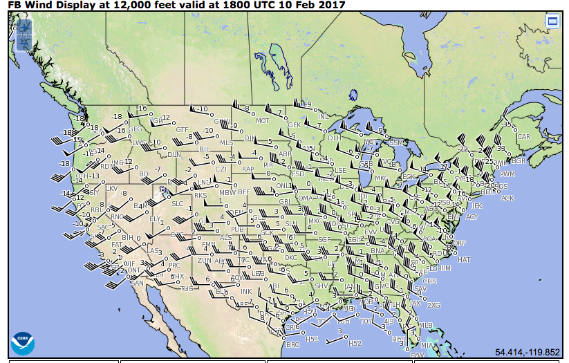 At least 30 knots. A quick paper napkin estimate would mean it would need about 40 knot winds to make it 600 miles. So it is certainly doable. ------- A turbo: Exhaust gasses go into the turbocharger and spin it, witchcraft happens, and you go faster. Mr. Doom and Gloom "King in the north!" "Slow is smooth... and also slow. | |||
|
thin skin can't win |
I just hope it wasn't armed! You only have integrity once. - imprezaguy02 | |||
|
| Sigforum Staff Pilot |
The operating range is in reference to the Line-of-Sight signal used to control the UAV. The MQ-1 (no knowledge of Shadow software) is loaded with a "Lost Link" logic so that when it loses link, it flies a pre-stored flight plan back to home base. The Lost Link flight plan is only as accurate as the person loading it. If the UAV changes operating areas and the operator neglects to load a new lost link plan, the UAV will revert to the last loaded lost link plan. In the absence of any lost link flight plan, the UAV will fly it's last commanded heading and altitude until it runs out of fuel. | |||
|
| The Persian |
It isn't a very big drone. There are RC planes bigger than the Shadow. ------- A turbo: Exhaust gasses go into the turbocharger and spin it, witchcraft happens, and you go faster. Mr. Doom and Gloom "King in the north!" "Slow is smooth... and also slow. | |||
|
| Shit don't mean shit |
Won't take long to get it out of the tree...It's windy as all hell here today...I am about 8 miles from there. | |||
|
| Member |
The link has a map showing the Shadow's route from AZ to CO. http://www.stripes.com/news/qu...-western-us-1.456505 Questions hover over Army drone’s 630-mile odyssey across western US By ALEX HORTON | STARS AND STRIPES Published: March 1, 2017 SAN ANTONIO — Mystery shrouds the rogue flight of an Army unmanned surveillance aircraft that was launched from southern Arizona on Jan. 31, flew hundreds of miles independent from human control and was found Feb. 9, broken apart in a tree outside Denver. The incident has raised questions: Why did the Shadow RQ-7Bv2 unmanned aircraft fly so far outside its 77-mile range, and how did the Army lose its aircraft for 10 days? The Shadow was part of a training mission conducted at Fort Huachuca in Arizona by soldiers from the 2nd Stryker Brigade of the 7th Infantry Division at Joint Base Lewis-McChord in Washington, according to Lt. Col. Fredrick Williams, a division spokesman. The aircraft quickly lost its connection with its ground crew after it was slung from its pneumatic catapult, said Tanja Linton, a Fort Huachuca spokeswoman. Linton confirmed Monday that the aircraft essentially flew the entire 630-mile journey outside of the Army’s control. Army officials have declined for weeks to release specifics about the incident, pending the results of an investigation. The Associated Press reported the aircraft, used to conduct aerial reconnaissance and surveillance for brigade operations, was missing a wing when it was found. An initial search of the area in Arizona failed to find the aircraft, and the Army concluded it likely disintegrated nearby, Linton said in a news release a week before the aircraft was found. Soldiers from Fort Carson in Colorado secured the aircraft and will send it back to Joint Base Lewis-McChord by rail, Williams said. It remains unclear how the flight of the $1.5 million aircraft with a range of about 77 miles reached a point eight times that distance. The Shadow, a 450-pound aircraft with a 20-foot wingspan, is flown mostly autonomously, with a preset bearing, altitude and wind speed, said Paul Stevenson, an Army aviation spokesman. The settings can be manually adjusted by an operator at a ground control station. The flight operator is paired with a payload operator, who controls the surveillance camera in real time. The aircraft operates by using a line-of-sight radio communication link with a ground control station within that range, according to specifications from Textron Systems, the Shadow’s manufacturer. Other unmanned drones are capable of remote piloting that uses satellite uplinks from across the world. Stevenson declined to release the distance endurance of the Shadow, though it is capable of flying for nine hours, he said. The 77-mile range is the limit of the ground control station’s link with the aircraft. It can fly farther than 77 miles in a circular pattern over an objective, for instance. It is possible the Shadow could reach the 630-mile distance with the fuel it has on-board, said Paul Scharre, a former unmanned system policy official at the Pentagon and director of the Future of Warfare Initiative at the Center for a New American Security, a Washington think tank. The National Weather Service recorded strong winds from the southwest into Colorado on Jan. 31, which also could have aided the Shadow on its long flight. Most unmanned aircraft systems like the Shadow are programmed to respond in different ways when a link is lost, Scharre said. Unmanned aircraft can loiter in the sky awaiting a link to reestablish, he said. The Shadow’s software can send the aircraft back to its launch point if the link is severed, but this Shadow not returning raises the possibility that its emergency programming failed. “It’s reasonable to think it just kept flying on the heading in whichever direction it was pointed last,” Scharre said. Losing a link is not unusual and it’s accounted for in the design of the aircraft, though the rogue flight and crash highlights broader concerns about unmanned aircraft, he said. “Without a person on board, even with a good link, you’re not going to have the same level of cognitive awareness,” Scharre said. “And if you lose signal link, you may have a limited ability to re-assert control over the aircraft. This would not happen with a person unless they went crazy or defected. That’s pretty rare.” If the emergency return programming failed, he said, it also points to the limitations of autonomous technology to adapt to changing conditions. “When programming is pushed outside its parameters, things can fall apart really fast,” Scharre said. A 630-mile odyssey Radar data provided by the Civil Air Patrol details an erratic path during the Shadow’s doomed flight. The aircraft flew east from Fort Huachuca in southern Arizona and banked sharply at 90 degrees after crossing into New Mexico. It flew north over the Gila National Forest and through sparsely populated areas and Native American reservations, according to a radar-tracking map. The Civil Air Patrol radar system lost the Shadow’s signal near the southern Colorado border as it went into mountains, about five hours and 10 minutes into its flight, said Lt. Col. John Henderson, vice commander of the Civil Air Patrol’s National Radar Analysis Team, which tracks and analyzes aircraft locations in the event of crashes, including this Shadow. Henderson said it must have maintained at least a 12,000-foot altitude to clear the mountain ranges. The Shadow was about 400 miles into its flight at that point, Henderson said, flying near Navajo City, N.M. It is 232 miles from Navajo City to Evergreen, a town west of Denver, where the Shadow was found in a tree by a hiker, The Associated Press reported. The estimated flying distance: 632 miles, essentially the entire distance without Army command and control. Re-examining safety and beliefs Textron Systems, which manufactures the Shadow for the Army, declined several times to discuss capabilities of the aircraft, citing the ongoing investigation. Morgan Stritzinger, a Textron spokeswoman, also declined to confirm any discussions between the company and the Army about safety and legal considerations of a wayward aircraft shuttling across a vast expanse of the American West before dropping at least 12,000 feet out of the sky near the country’s 19th most populated city. Other mishaps involving Shadows have occurred in recent years. In 2014, a Shadow aircraft crashed in Pennsylvania and was struck by a car. In 2011, a C-130 cargo plane collided with a Shadow in the air over Afghanistan. The Shadow, which is also fielded by the Marine Corps, has an extensive operational history in Afghanistan and Iraq. The aircraft is used to conduct surveillance in ongoing operations against the Islamic State group in Iraq, according to Army releases. The aircraft is slated to replace the reconnaissance mission of the Army’s OH-58 Kiowa Warrior helicopters as part of a restructuring plan started in 2014. All 10 divisional aviation brigades across the Army will field the Shadow aircraft alongside AH-64 Apaches by 2019, according to Army planning documents. The Shadow’s pairing with Apache crews will expand surveillance and scouting abilities by patching in direct video feeds of distant objectives and enemy positions, the Army has said. As the use of unmanned aircraft rises, it’s important to re-examine beliefs and misconceptions about technology, Scharre said. Most people understand glitches and software failures occur just by using cell phones and computers, for instance, but often do not apply the same understanding to unmanned aircraft, he said. No technology can quite match the reasoning of a human, Scharre said. “Imagine a soldier on Fort Huachuca getting lost doing land navigation," he said. “He’s not going to keep going and wander into Colorado.” Horton.Alex@stripes.com Twitter: @AlexHortonTX | |||
|
| Powered by Social Strata | Page 1 2 3 |
| Please Wait. Your request is being processed... |
Topic Closed© SIGforum 2024