SIGforum.com  Main Page The Lounge Missouri members - stay safe and prayers if you are affected by flooding
The Lounge Go | New | Find | Notify | Tools | Reply |
| Member |
This subject touches me because we were flooded out of our home exactly 6 years ago tomorrow. Several rivers in Missouri are well above record levels today. My prayers and thoughts out to any and all affected. Waking up on a Sunday morning to see your road washing away and telling your wife to "grab the baby" is something I pray to never re-live. https://water.weather.gov/ahps..._forecast.php?wrr=10 | ||
|
| Lawyers, Guns and Money  |
Thanks, dusty3030. We aren't much more than a mile from the meramec river. I woke up to a phone call from my parents. The sump pump wasn't running and they were bailing in the basement. I went over there for a couple of hours and bailed water from the sump to the bar sink drain which was the closest available. Eventually we were able to get a hold of the raintight guy who came pretty quick and installed another pump. He's a good guy (a gun guy "Some things are apparent. Where government moves in, community retreats, civil society disintegrates and our ability to control our own destiny atrophies. The result is: families under siege; war in the streets; unapologetic expropriation of property; the precipitous decline of the rule of law; the rapid rise of corruption; the loss of civility and the triumph of deceit. The result is a debased, debauched culture which finds moral depravity entertaining and virtue contemptible." -- Justice Janice Rogers Brown "The United States government is the largest criminal enterprise on earth." -rduckwor | |||
|
| Gone but Together Again. Dad & Uncle  |
Thank you! Although our home is in an area that does not flood, back at the "great flood" of 1993 our office was completely under water. They've improved the levee since then and there are now tons of new offices/shopping/restaurants/etc in the Chesterfield Valley - fingers crossed. However back to our home I've been shop-vacuuming our basement every 4 hours | |||
|
Living a strange life |
Good luck guys. Hate to see this so soon after The 2015 floods. I hope downtown Eureka makes out better this time. | |||
|
| Living a strange life |
Not looking good. Forecast to be 2 feet short of the 2015 flood. https://water.weather.gov/ahps...p?wfo=lsx&gage=erkm7 | |||
|
| Muzzle flash aficionado  |
Word from my cousin in the NW corner of MO is no flooding on his farm, but he heard of flooding around Van Buren (south central). flashguy Texan by choice, not accident of birth | |||
|
| I run trains! |
West Plains was hit pretty hard, as were other areas in south central and southwest MO. I do know that W Plains was without cell and power to a lot of town until mid-afternoon today. Luckily most of that has been restored, however Hwy 63 is still under water north of town. I-44 is underwater just west of Rolla @ Jerome, the Gasconade river is still rising. We got around 8.5" of rain at the house since this all started late Friday. Forecast calls for a couple clear days but more rain come Wednesday. This is the railroad bridge at Jerome over the Gasconade earlier today.  Success always occurs in private, and failure in full view. Complacency sucks… | |||
|
| Member |
Saw reports of roads washed out in Arkansas due to heavy rains also. Jim | |||
|
E Plebmnista; Norcom, Forcom, Perfectumum. |
By tomorrow morning, there will only be one road open between home and work and it will be crowded. I may just get a room tonight and skip the morning commute. ================================================ Ultron: "You're unbearably naive." Vision: "Well, I was born yesterday." | |||
|
| Lawyers, Guns and Money |
We've been asked by the Water Company to conserve water as the Meramec treatment plant will be temporarily closed. I-44 will close tonight as rising Meramec River threatens roads, homes, businesses ... 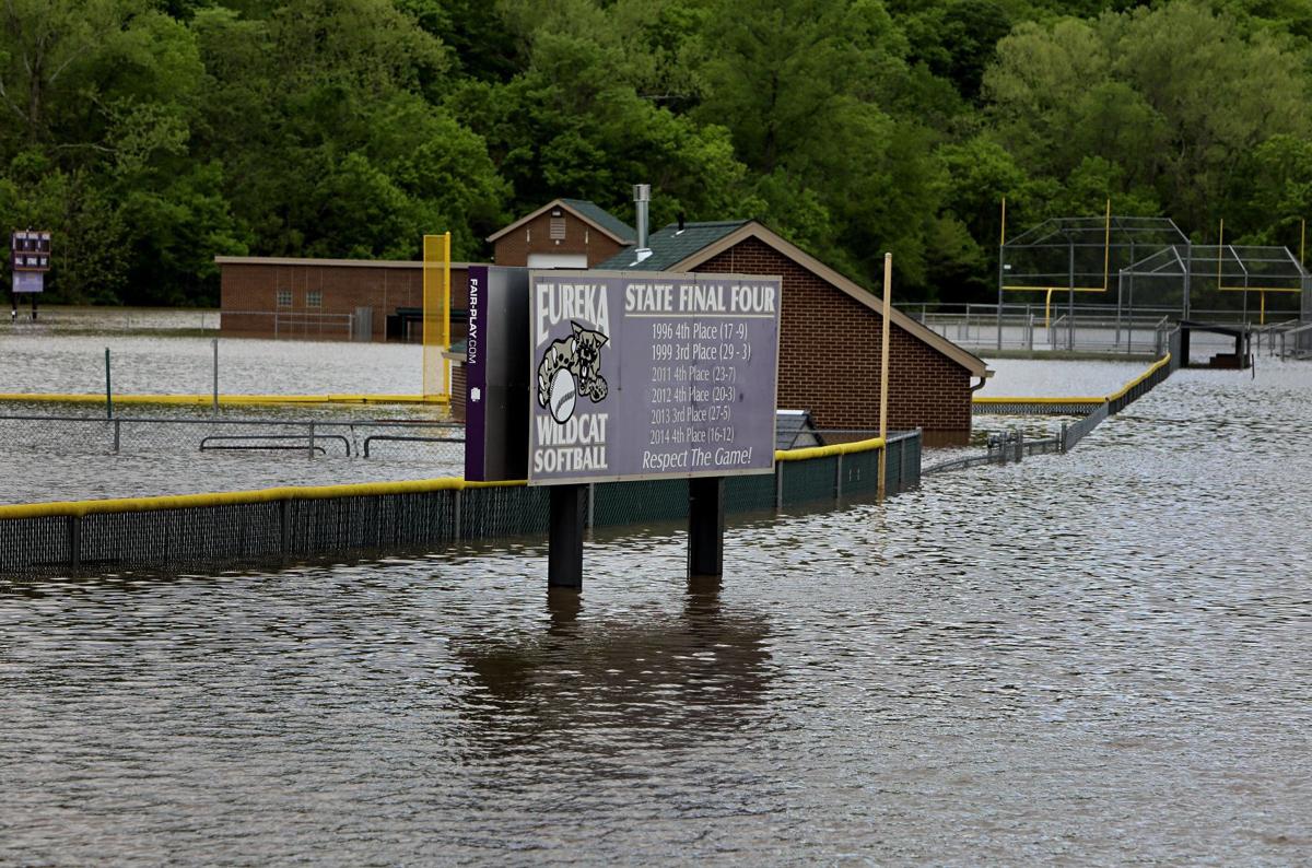 My daughter played softball on this field. 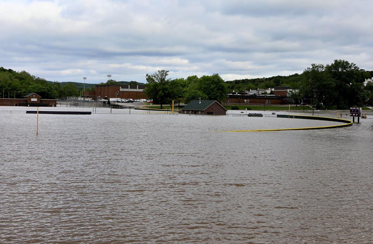 "Some things are apparent. Where government moves in, community retreats, civil society disintegrates and our ability to control our own destiny atrophies. The result is: families under siege; war in the streets; unapologetic expropriation of property; the precipitous decline of the rule of law; the rapid rise of corruption; the loss of civility and the triumph of deceit. The result is a debased, debauched culture which finds moral depravity entertaining and virtue contemptible." -- Justice Janice Rogers Brown "The United States government is the largest criminal enterprise on earth." -rduckwor | |||
|
| Member |
My house isn't effected, but my commute most definitely will be. Still not sure if my route will be open or not. | |||
|
| Lawyers, Guns and Money |
Overbuilt levees upstream reignite skepticism about ones near St. Louis About 40 percent of levees along the Mississippi River in the Army Corps of Engineers district north of St. Louis are built higher than their authorized heights, according to the agency’s own findings. The Corps’ Rock Island District, which covers an area beginning about 60 miles upstream from St. Louis, reports that about 80 out of 202 miles of levee systems it surveyed are improperly high, based on data yet to be publicly released. “Some of those were between 2 and 4 feet above their authorized elevation,” said Scott Whitney, the Corps’ Rock Island District flood risk manager and chief of project management. “The revelation is out there that levee districts throughout this region have taken, in some cases, some pretty extreme measures to protect themselves.” That protection, he notes, has come “at the cost of others,” with the added levee height leaving other areas more vulnerable to redirected floodwater. Whitney said the district is still developing a hydraulic model to understand how far-reaching the levees’ combined impact on flooding has been, including whether the St. Louis area has been affected. But the chronically overbuilt levees to the north cause some to wonder whether the problem is more widespread, rekindling some skepticism about levee heights around St. Louis. Last year, the issue gained visibility when an independent group found the levee in Valley Park, along the recently flooded Meramec River, to be as much as 8 feet higher than what was believed to be its proper height. The Corps’ St. Louis District maintains that Valley Park’s levee is properly built and that it did not worsen local flooding in late 2015 and early 2016. Officials confirmed, however, that they are conducting similar efforts to examine the heights of the approximately 50 federally built levees in the St. Louis district, including the one in Valley Park. The surveys began late last year and are expected to be complete by March 2018. “It’s pretty much been a result of the ongoing controversies up north,” said John Osterhage, levee safety program manager for the St. Louis district. Those upstream disputes about levee heights have simmered for years. Many of the Rock Island District’s levees are made of sand, making it possible for bulldozers to push them higher to ride out floods. That was the case in 2008, when a number of the region’s levee districts were allowed to temporarily make emergency modifications in anticipation of flooding. But the structures are not always returned to their original, authorized elevations. Corps officials said mounting suspicions spurred them to resurvey the area’s levee heights. Levee debates have been especially loud in areas next to the Sny Island Levee and Drainage District, which stretches along about 60 miles of the Illinois riverfront, from Quincy to Belleview. The Sny, the largest levee-protected area overseen by the Corps’ Rock Island office, has come under fire from government agencies and flood-damaged farmers for supposedly exceeding its authorized height. But the numbers revealed by the Rock Island District’s newly redone surveys show that the Sny is not the lone offender. Ten systems across seven different levee districts in Missouri, Illinois and Iowa had the majority of their construction exceed the authorized design grade by more than 2 feet. Whitney says that even some within the Corps worry that the findings could hint at a systemic problem. “Given what we’ve observed here, it’s taken away a lot of the security that a lot of other districts have felt,” said Whitney. “While we had suspicions and had identified some issues and concerns, this survey delineated a much bigger problem.” Those concerns are shared by St. Louis-area river and flood policy experts. “I don’t know why the problem would be more severe in the Rock Island District,” said David Stokes, executive director of Great Rivers Habitat Alliance, an organization devoted to river management issues. “I mean this isn’t a few inches higher,” Stokes added. “There’s definitely a problem (with) levee districts ignoring the rules.” Osterhage, though, said the St. Louis District doesn’t “anticipate having issues to the extent that they do” upstream, explaining that many local levees are clay-based and are not reshaped prior to floods. Levee elevations can go unchecked for years at a time. Even with federally built levees, maintenance is often left to independent levee districts and sponsors, who must apply for permits to alter the structures. The Corps conducts visual levee inspections every year, which usually consist of cursory glances from a vehicle to detect any glaring damage or levee modifications. More thorough inspections that survey height along the tops of levees are generally done every five years, Osterhage said. Critics maintain that levee systems are a “counterproductive” tool for flood control. “With our so-called flood prevention efforts, high levees are counterproductive, just magnifying the potential damage,” said Bob Criss, a professor in the Department of Earth and Planetary Sciences at Washington University. “The water’s gotta spread out.” Some argue that reliance on levees should be diminished in the long run, but that more immediately, the structures should be subject to better enforcement, since coordinating heights with other levees is essential. “If levees aren’t at the heights they’re approved for, then nobody else knows how to plan,” said Stokes, adding that the Corps or other regulatory agencies must compel them to come down to their proper elevation. But levee districts have shown an unwillingness to comply. Whitney said only one of the levee districts recently found to exceed its authorized height has so far cooperated with the Corps in trying to discuss a solution. The rest, he said, are reluctant to go through the procedure. Complicating matters further, stronger flood protection is increasingly coveted, with an unusual number of major floods taking place in recent years — a symptom consistent with more erratic trends in precipitation predicted by climate change. “We’re in an extremely wet period,” said Whitney, noting that several of the region’s top flooding events on record have occurred in the last decade. “We’ve had a number of those in the last several years. People think, ‘My God, I’ve had three 100-year flood events in the last five years.’” http://www.stltoday.com/news/l...f6-becac7089b3f.html "Some things are apparent. Where government moves in, community retreats, civil society disintegrates and our ability to control our own destiny atrophies. The result is: families under siege; war in the streets; unapologetic expropriation of property; the precipitous decline of the rule of law; the rapid rise of corruption; the loss of civility and the triumph of deceit. The result is a debased, debauched culture which finds moral depravity entertaining and virtue contemptible." -- Justice Janice Rogers Brown "The United States government is the largest criminal enterprise on earth." -rduckwor | |||
|
| Lawyers, Guns and Money |
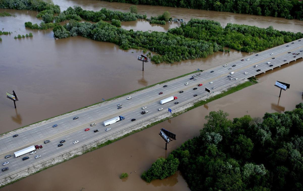 Interstate 55 will be closed sometime overnight as the Meramec River continues to rise, the Missouri Department of Transportation says. The nearby Meramec River crossings at Lemay Ferry and Telegraph roads are also expected to close overnight, according to Greg Horn, St. Louis district engineer for the Missouri Department of Transportation. "So you all are going to have to decide what side of the river you want to be on before you go to bed tonight, because you're not going to be able to go back and forth," Horn said. The closures of 55, Lemay Ferry and Telegraph would effectively cut off the southern part of the metro area. Starting from the west, Highway F south of Pacific is already closed at the Meramec; Highway 109 in Eureka is closed at the river; Interstate 44 closed Monday night; Highway 141 crosses the Meramec but is closed before Interstate 44; Highway 30 (Gravois Road) was closed; Highway 21 (Tesson Ferry Road) is expected to close Tuesday; and I-55, Lemay Ferry and Telegraph are expected to close overnight. During similar flooding in December 2015, Horn said, the closure of I-55 caused the biggest traffic problems area-wide, exceeding even the shutdown then of Interstate 44. "Alternate routes? There are really no good alternate routes," Horn said. "Cape Girardeau is probably the closest way, so that's a long way." http://www.stltoday.com/news/l...83-f2ebd2dfb6fd.html "Some things are apparent. Where government moves in, community retreats, civil society disintegrates and our ability to control our own destiny atrophies. The result is: families under siege; war in the streets; unapologetic expropriation of property; the precipitous decline of the rule of law; the rapid rise of corruption; the loss of civility and the triumph of deceit. The result is a debased, debauched culture which finds moral depravity entertaining and virtue contemptible." -- Justice Janice Rogers Brown "The United States government is the largest criminal enterprise on earth." -rduckwor | |||
|
| Member |
Randolph County, Arkansas and especially the town of Pocahontas is getting thrashed. Terrible. http://www.kait8.com/story/353...ee-breaches-reported | |||
|
| Unapologetic Old School Curmudgeon  |
My mother in laws neighborhood is an island. Her house is up high but there is no way in our out. Talked to her last night to make sure she had water and food. Not sure what I could have done if the answer was no. Don't weep for the stupid, or you will be crying all day | |||
|
| Lawyers, Guns and Money |
You know the flooding is bad when "Noah's Ark" daycare is closed. "Some things are apparent. Where government moves in, community retreats, civil society disintegrates and our ability to control our own destiny atrophies. The result is: families under siege; war in the streets; unapologetic expropriation of property; the precipitous decline of the rule of law; the rapid rise of corruption; the loss of civility and the triumph of deceit. The result is a debased, debauched culture which finds moral depravity entertaining and virtue contemptible." -- Justice Janice Rogers Brown "The United States government is the largest criminal enterprise on earth." -rduckwor | |||
|
SIG's 'n Surefires |
M-11 Jr lives in a small river town 100 miles south of STL. They already have significant flooding, but are gearing up for what comes down river- he's issuing waterwings, floaties and pool noodles to all of his officers. "Common sense is wisdom with its sleeves rolled up." -Kyle Farnsworth "Freedom of Speech does not guarantee freedom from consequences." -Mike Rowe "Democracies aren't overthrown, they're given away." -George Lucas | |||
|
| Powered by Social Strata |
| Please Wait. Your request is being processed... |
SIGforum.com Main Page The Lounge Missouri members - stay safe and prayers if you are affected by flooding
The Lounge © SIGforum 2024